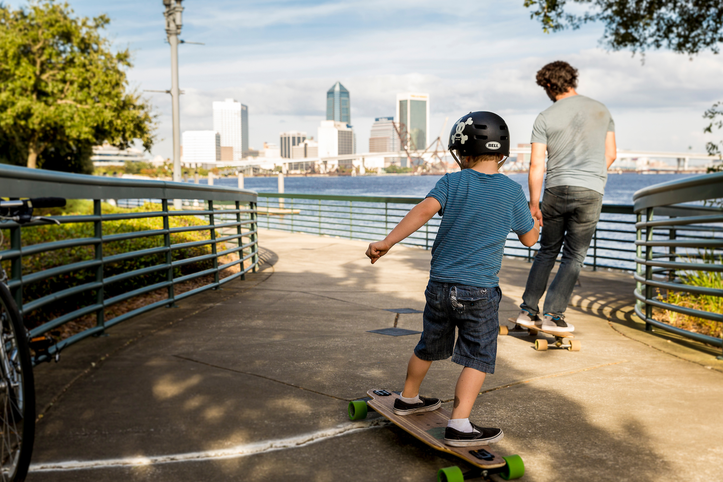
While Northeast Florida is traditionally a sprawling, car-centric community, Downtown Jacksonville is undergoing a transformation to a major multi-modal transportation hub. A $50 million regional transportation center opened in Spring 2020, and a $350 million innovation corridor is in the works. Outdated bridge ramps are coming down while road diets and two-way street restorations are in the works. Additionally, bike-ped loops, riverwalk enhancements and greenways are being constructed to allow the community to take better advantage of Downtown’s waterways and amenities. As the community grows and changes, the focus of the Downtown Investment Authority and its partners is on sustainable infrastructure that is economical and resource-friendly far into the future.
The Jacksonville Transportation Authority is transforming downtown mobility with the Ultimate Urban Circulator (U2C). U2C is a multi-phased program aimed at converting and expanding the automated people mover (Skyway) into an autonomous vehicle (AV) network. By transforming the current Skyway, extending the reach within the urban core through the Bay Street Innovation Corridor and expanding beyond into adjacent neighborhoods, U2C supports the vision of a vibrant, revitalized and better-connected Downtown Jacksonville. Find out how we’re bridging destinations on both sides of the St. Johns River.

_Page_01")

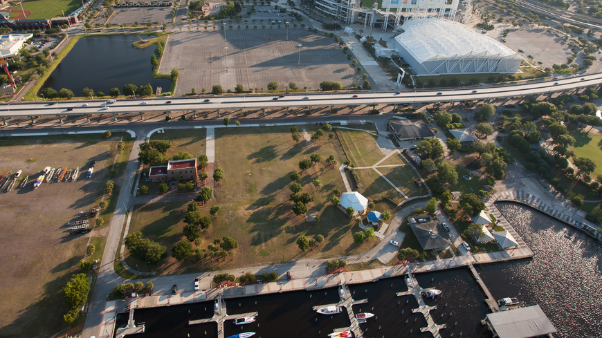
Artist Walk: Helping provide a critical connection between the Northbank and Southbank Riverwalks, this linear park space under the Fuller Warren Bridge includes a multi-use trail connection, parking, pedestrian corridors, landscaping and other amenities. It will support the Riverside Arts Market, which has been open along the banks of the St. Johns River on Riverside Avenue since 2009, and provides a much-needed public space.
Fuller Warren Bridge: Completed in April 2023, the Shared Use Path along the Interstate 95 Fuller Warren Bridge connects the Riverside Arts Market and the future Artist Walk to the exit ramp at Palm Avenue in San Marco for pedestrians and bicyclists. In San Marco, the path will connect to the Southbank Riverwalk and planned Nira Street loop.
This 50-mile trail project is proposed to be an exciting East Coast Greenway trail development. Jacksonville leaders have asked for the loop to be added to the Greenway’s spine route, which would connect the East Coast Greenway to Downtown Jacksonville. The trail will enhance developments along the north and south banks of the St. Johns River. It will connect major industrial and business redevelopment areas of the city near TIAA Bank Field while supporting long-desired community enhancement and redevelopment efforts in some of Jacksonville’s older neighborhoods.
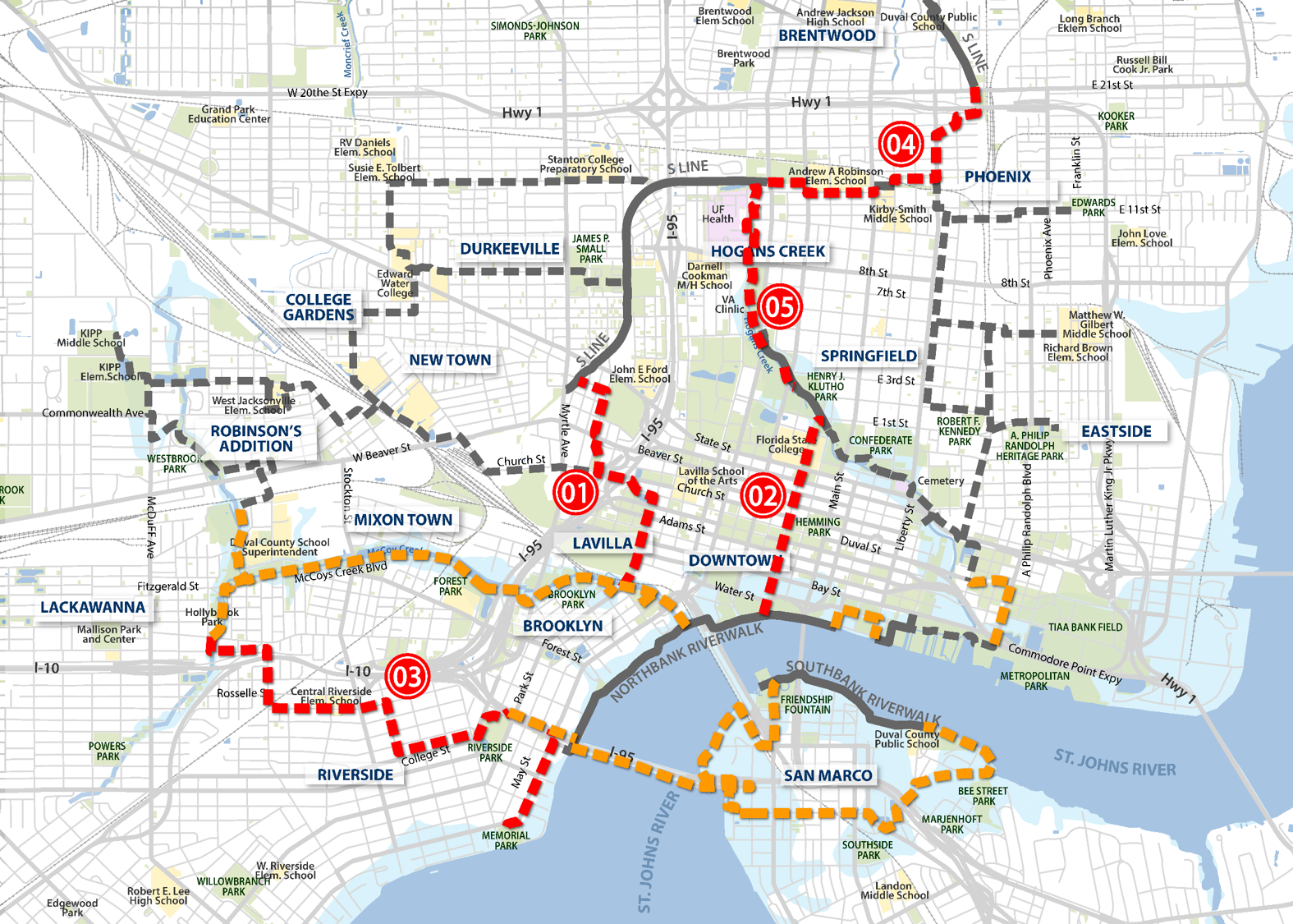
In Spring 2019, the Jacksonville City Council approved Groundwork Jacksonville’s Emerald Trail Master Plan to create a 30-mile network of bicycle and pedestrian trails that will connect Downtown to 14 historic neighborhoods, 18 schools, two colleges and nearly 30 parks. Phase I is a 1.3-mile Model Mile project to connect the existing S-Line Rail Trail in Springfield to Park Street and the McCoys Creek Greenway. The estimated cost of the Emerald Trail network is $31 million plus land acquisition, and the project is expected to take 10 years to complete.

The Hogan Street Cycle Track provides a missing connection between the Hogan Creek Greenway trail and the Northbank Riverwalk. The trail will begin on the northern end at Hogans Creek and will interact with the Florida State College at Jacksonville (FSCJ) campus as a shared-use street. The segment within Downtown will become a cycle track along the west side of Hogan Street adjacent to the pedestrian sidewalk. The one-way roadway of Hogan Street will be modified to remove one of the two travel lanes. This proposed roadway modification and cycle track design is proposed from West State Street south to Bay Street. The suggested design standard of the cycle track is to create a safe and inviting pedestrian and bicycle dominated corridor while better accommodating outdoor dining. The final block from Water Street to the Northbank Riverwalk will have the cycle track and pedestrian area transition into a shared-use side path.

The first phase of the Emerald Trail is the Model Mile project, the 1.3-mile connection between the south end of the existing S-Line Rail Link to the intersection of Park Street and Stonewall Street, near the Convention Center. The concept of the model project is to quickly build a portion of the trail that will be highly utilized and will offer the community a tangible example of what the finished trail can be.
The Model Mile project broke ground August 2021, and construction continues.
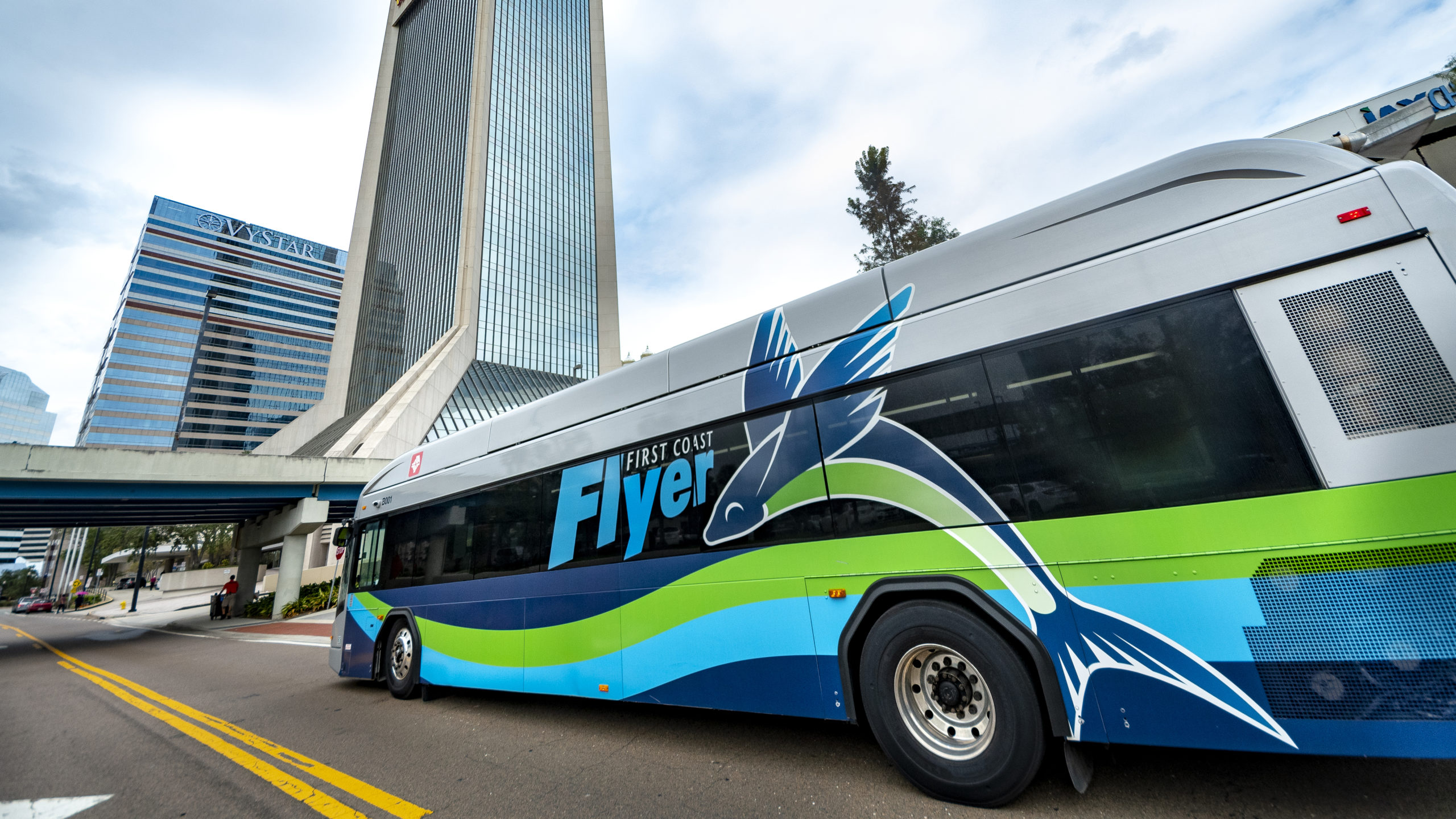
Launched in 2014, the $151.8 million First Coast Flyer Bus Rapid Transit (BRT) connects Jacksonville’s Northside, Southside and beach communities. Completed in 2021, the 58-mile system is the largest in the Southeastern U.S. and involved a $138 million investment that included $114 million in federal and state funding.
In the Sports & Entertainment District, a large portion of the elevated Hart Bridge ramp connector was removed to bring the expressway down the street level and open up parcels on and near the St. Johns River for redevelopment.

East of Main Street, this future Emerald Trail segment will extend the Hogans Creek Greenway along the creek corridor to the south of Duval Street where the segment will create a loop connection on the east side of Downtown with the Northbank Riverwalk and TIAA Bank Field, Veterans Memorial Arena and 121 Financial Ballpark sports venues.

The waterfront of the Jacksonville Performing Arts Center, located directly across the river from St. Johns River Park, will be transformed into an interactive multifaceted musical commons. Built around the theme Jacksonville’s Musical Heritage, plans for the riverfront at the Times-Union Center for the Performing Arts call for a garden highlighting musicians and composers with Jacksonville ties, a children’s music play space and a new outdoor wall projection venue with livestreamed performances and movie projections. DIA is contributing to the project by handling video production of a nightly projection shown on the building’s riverfront facade.

Completed in 2020, this facility serves as the multimodal station for all public transit in the region integrates a 40,000-square-foot transfer facility for the First Coast Flyer Bus Rapid Transit (BRT), Skyway/U2C, rideshare and bike share, and a 10,000-square-foot Greyhound/MegaBus Intercity Bus Terminal.
Investment: $57.3 Million

This public marina is envisioned as a daylighted basin for approximately 50 boats of varying sizes with designated water taxi landing, fuel dock, pump-out station and marina office with restrooms and showers.

As part of the development strategy for Downtown’s LaVilla district, Lift Ev’ry Voice and Sing park is being expanded under a design that celebrates James Weldon Johnson and the African-American experience. The park, which commemorates Johnson’s contributions to the nation, will invite people from all walks of life to honor this important Jacksonville native and his brother, with whom he wrote the iconic song that gives the park its name. Designed by renowned landscape architect Walter Hood, the park will be linked to 15 other historic neighborhoods and Downtown via the Emerald Trail.

Partially buried under decades-old development, McCoys Creek flows through Brooklyn into the Saint Johns River. The restoration of McCoys Creek will uncover the waterway to create a picturesque recreational destination, reduce flooding in the area and remediate environmental issues. Restored bulkheads and creekside development will allow for outdoor dining, bike and pedestrian amenities and a new kayak launch.

McCoys Creek Park at One Riverside Ave will include approximately 2 acres of riverfront public park space along McCoys Creek. The project supports the completion of the McCoys Creek Restoration and Resiliency Project and enhances the adjacent One Riverside private development. Features of the park include a natural bank along the creek on the park side, the Emerald Trail multi-use path on the west side of the creek, and a pedestrian bridge crossing the creek mid-park. The park will be accessible from Riverside Avenue as well as the Northbank Riverwalk.

Existing roadway infrastructure within Downtown’s Brooklyn Neighborhood will be modified to enhance pedestrian and bicycle connectivity and improve traffic safety. Improvements include adding a cycle track (two-way bicycle traffic), on-street parking and expanded sidewalk areas while also reducing roadway widths to allow for safer pedestrian crossings and the planting of streetside trees. The goal is to create a more multi-modal street within the urban core linking LaVilla and the Regional Transportation Center with the nearby Riverside neighborhood and Five Points retail/dining/entertainment area. Enhanced pedestrian experiences will also promote economic development along the corridor. Once completed, the project will connect Park Street to the Emerald Trail Model Project as well as the McCoys Creek Greenway.

After a seven-month selection process, a substantial amount of public engagement and the submission of three outstanding designs, the Perkins&Will design team was named winner of the Riverfront Plaza (FKA The Landing) Design Competition. The winning design – dubbed One Park Jax – boasts a central lawn, a destination play space, a river terrace, a park pavilion building, a hotel and sky garden, which includes outdoor dining options, a bike and pedestrian connection to the Main Street bridge, and an iconic sculpture situated atop civic stairs that is undeniably unique and authentic to Jacksonville.
Two acres of the Riverfront Plaza space are reserved for development.
To learn more about the Perkins&Will design, visit: https://dia.coj.net/News/Perkins-Will-Wins-Riverfront-Plaza-(FKA-The-Landin.

Reconstructed to better support new investment and diverse community needs, the new Riverplace Boulevard has two fewer automobile lanes in favor of enhanced pedestrian amenities, protected bicycle lanes, improved on-street parking and low impact design (LID) stormwater raingardens. The plan also includes enhanced bus transit and service and utility enhancements.

RiversEdge: Life on the St. Johns — with its vision for a sustainably designed mixed-use development on a long-vacant, 30-acre riverfront site — will encourage a healthy lifestyle. The development will include more than four acres of public park spaces, including a large central riverfront park, and will tell the story of Jacksonville’s extraordinary medical facilities through art, exercise, gardens and interactive features. Active water access abounds with a marsh boardwalk and an extension of the Southbank Riverwalk, as well as transient boater slips and a kayak launch site. With scenic views of both the river and the Downtown skyline, this unique setting will be a place that empowers residents and visitors to pursue and achieve wellness in their everyday lives.
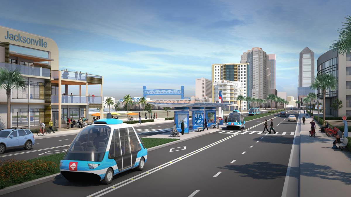
This collaboration with the City of Jacksonville, North Florida TPO, JEA and JAX Chamber will create a national model for the deployment of autonomous vehicles. The existing Skyway will be converted and smart technologies such as dynamic signals, connected intersections, integrated data exchange, pedestrian sensors, flood warning sensors and power consumption reduction will be installed.
Investment: $350 Million
In 2015, the City of Jacksonville adopted a revised Community Redevelopment Area (CRA) plan for the Northbank of Downtown, which includes a specific project for the reintroduction of two-way street systems within the Northbank. Subsequent mobility plan updates and other transportation projects have consistently carried forward this directive, and funds have been set aside within the CRA to begin implementation. The return to two-way streets and resulting slower speeds are shown to stimulate economic growth and increase property values; facilitate more efficient use of on-street parking and ride share; enhance retail visibility and promote retail occupancy rates and success; improve walkability and increase pedestrian safety and pedestrian activity on the sidewalk; and increase residential demand and perceived quality of life for residents. Forsyth Street and Adams Street are both identified as streets prioritized within the CRA Plan for two-way conversion. Segments of both streets lie within DIA’s targeted dining districts, and their conversion to two-way configuration complements other public and private redevelopment efforts. The design phase of this project is underway.

Shipyards West Park will transform long-vacant land into a world-class riverfront park inclusive of complimentary amenities that will provide the missing link between Riverfront Plaza and Metropolitan Park. Design for the Shipyards West Park was awarded to Agency Landscape + Planning.

This effort includes the design and construction to extend the Southbank Riverwalk to include amenities such as pavers, benches, and other amenities as well as the completion of an overland multi-use loop trail that is aesthetically integrated with the Southbank Riverwalk.

St. Johns River Park, located on the Southbank waterfront between the Main Street and Acosta bridges and home to Friendship Fountain, is undergoing a major transformation. Through careful curation, a more vibrant year-round public space will take shape over the next two years. Built around the theme Exploring the St. Johns River, plans for the park call for a botanical garden, themed play park, splash pad, concessions and fountain upgrades. The node will tell the story of the indigenous Timucuan people, Ribault’s landing in 1562 and the Ft. Caroline settlement, and botanist and horticulturist John Bartram’s travels through Jacksonville. Central to the park will be an upgraded fountain representative of the flow of the St. Johns and including fully functional dancing jets choreographed to music and lights.